Standard synthetic aperture RADAR interferometry (InSAR), is a method which is applied to phase component of two SAR images acquired from relatively close positions to form the interference patterns between the two images. If the Earth surface deforms between the two acquisitions, the surface displacement with sub-centimetre accuracy can be theoretically mapped in the absence of atmospheric artefacts (Sarti et al., 2006). During the two past decades, InSAR has evolved from a theoretical concept to a method, and has revolutionized a wide range of earth science fields. InSAR has been widely used as a power-proved method to reveal centimetre-scale deformation of the Earth surface resulting from earthquakes and volcanic events, in addition to sand dunes migration, glaciers flows, land slides creeping movements and subsiding areas (Bamler and Hartl, 1998).
The measured phase difference between two corresponding pixels of an interferometric pair contains variations of the satellite-ground distance change during the acquisition time interval, and is expressed by the interferometry equation after a precise co-registration of the two images (Reigber et al., 2007) as:
where φtopo is the topography phase signature, φflat is the flat earth phase caused by the imaging geometry, φdisp. is the differential displacement pattern, φorbit is the phase error caused by inaccurate orbit parameters, φatm. is the atmospheric artefacts, and φnoise refers to noise contribution.
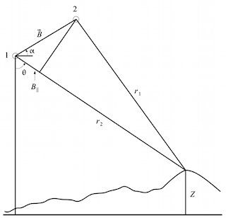
Differences in path length of a fraction of a wavelength (i.e., millimetres) can be measured from the phase offset between coherent patches of surface in two SAR images. The interference pattern is a function of (1) the topography (z), (2) any displacement of the surface in the look direction (θ, also called incidence angle), that has taken place between the two image acquisitions, and (3) the spatial separation (known as the baseline, ) of the SAR images in space at the image acquisition time (Figure 1), and (4) in the case of repeat pass interferometry, changes in atmospheric path length between the two dates of acquisition. The displacement component of the interferogram is independent of the baseline, but it should be noted that there is no sensitivity to motion that is perpendicular to θ. The sensitivity of the measurements to the topography is proportional to the baseline . For example, if the baseline is zero then there is no sensitivity to topography and the interference pattern depend on displacement only (Bamber and Rivera, 2007).
|
Figure 1. Geometry of the repeat-pass interferometry (Rosen et al., 1996) |
When two interferometric SAR images are not acquired simultaneously (repeat-pass interferometry), several fundamental problems interfere in detection and isolation of the deformation signature in the processed interferograms.
Change of the backscattered phase between observations is the first problem in isolating the motion signature. The topography itself is the second major problem. Atmospheric effects on the RADAR signal is the third problem. When the sensor observing the Earth, RADAR signals propagate through the atmosphere, which induces additional phase shifts that are not accounted for in the InSAR geometrical models.
References
Bamber, J. L., and Rivera, A. (2007). A review of remote sensing methods for glacier mass balance determination. Global and Planetary Change, 59(1-4), 138-148.
Bamler, R., and Hartl, P. (1998). Synthetic aperture radar interferometry. Inverse Problems, 14(4), R1-R54. doi:10.1088/0266-5611/14/4/001.
Reigber, A., Erten, E., Guillaso, S., and Hellwich, O. (2007). Idiot: A free and easy-to-use software tool for DInSAR analysis. Proceedings of Envisat Symposium (ESA SP-636, July 2007) (pp. 23-27). Montreux, Switzerland.
Rosen, P. A., Hensley, S., Zebker, H. A., Webb, F. H., and Fielding, E. J. (1996). Surface deformation and coherence measurements of Kilauea Volcano, Hawaii, from SIR-C radar interferometry. Journal of Geophysical Research, 101(E10), 23109-23125. AGU. doi:10.1029/96JE01459.
Sarti, F., Briole, P., and Pirri, M. (2006). Coseismic fault rupture detection and slip measurement by ASAR precise correlation using coherence maximization: application to a north-south blind fault in the vicinity of Bam (Iran). IEEE Geoscience and Remote Sensing Letters, 3(2), 187-191. IEEE. doi:10.1109/LGRS.2005.852475.
No comments:
Post a Comment